
Jim Fair
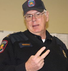
Sgt. Randle Ballenger, left, said data is available online to the public to help drivers maneuver around dangerous roads and intersections. Officer Clay Anderson assisted in the presentation.
Jim Fair
Greer Police Chief Dan Reynolds said, "What our goal is is to reduce or minimize the risk of the accidents."
Jim Fair
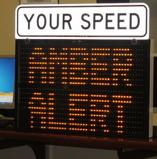
Mobile, digital signs, introduced at City Council last year, are 70 percent effective in drivers slowing down when they are speeding through the radar beams.
“I can tell you that Hwy. 29 towards Taylors, South Buncombe and Brushy Creek, Suber (Road) and Brushy (Creek Road)) and Suber Road and Hwy. 29 are where the collisions are occurring,” Sgt. Randle Ballenger said. “If you travel through the city of Greer or live in the city of Greer, why not take the opportunity to learn where some of these collisions are. Our goal is to reduce the number of injuries and collisions.”
The traffic team worked nearly 1,000 vehicle accidents during the last quarter of 2014, according to the statistics provided by Ballenger and posted online.
The comprehensive report details where collisions occur and their frequency, day and time, factors contributing – distracted/inattention, failure to yield right of way, driving too fast for conditions and following too closely – to the collisions and types of injuries. “You get a clear picture when you look at a three-month average where collisions are occurring,” Randle said. “It also tells us which category of road it occurs on, that is primary, secondary or one of the county roads.”
The color-coded injury report defines each occupant’s status. January’s report indicated there were 265 non-injured (blue) while the remaining 32 (9.2 percent) included one fatal, 13 possible injury and 18 non-incapacitating.
“The bigger we can make that blue section bigger the better off we will be,” Ballenger said. That is where enforcement comes in. A 50-miles per hour collision is far worse than a 30-miles per hour collision.
The report generated within a state system can produce collision reports quicker. “It has barcode scanners that can scan the license and registration of a car and it allows us to pull basically any statistics from the collision that we need to,” Ballenger said,
“The traffic strategies are three-pronged – education, engineering and enforcement,” Chief Dan Reynolds said.
“The first thing we look at is engineering. Is there something about the intersection or roadway that is causing the accident incident? If it is we get with the state and our public works department to fix that.
Randle said a timing change on the traffic lights at Hwy. 29 and Buncombe Road added more time for vehicles and pedestrians to maneuver the wide intersection. A guardrail was added at Brushy Creek and Main Street to help prevent vehicles from falling into a deep hole.
Making the collision reports available online is the continuing education part of city police.
Ballenger also reviewed new electronic road signs that were introduced at city council last year. The two 18-inch signs cost $4,000 each, are tamper-proof, and can display messages, sent digitally across town, of six characters on each of two lines. They replace the bulky signs that were trailer-mounted.
“They are not cheap but they are worth their weight in gold,” Reynolds said of the enforcement tool. “Because of the information it gets, it keeps us from having an officer sit at a location and capture the data we need.” Reynolds said he is thinking about doubling or tripling the number of signs.
The data can be monitored in real time with officers able to access information through the cloud. “It tells what time the cars are going through and how fast they are going,” Ballenger said.
“We’re running about 70 percent effectiveness,” Ballenger said. “When vehicles enter the radar beams it knows your speed and tracks you until you leave. About seventy percent of the people slow down from the time they first encounter the time. It’s as effective as a patrol car sitting there.”
Reynolds said using enforcement tools is a means to make the city’s roads safer.
“We prefer not to write a ticket, we don’t rely on that revenue as some communities do,” Reynolds said. “We want to slow people down. What our goal is is to reduce or minimize the risk of the accidents – meaning fewer injuries, less damage to the vehicle.
“And if people are driving slower it makes sense it’s a matter of physics it means they are going to be less apt to have a serious accident, hurt themselves and others.”
Click here to see the report.