Greer Station Association
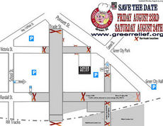
This map will help cookers, vendors and the public to navigate downtown during this weekend's Sooie't Relief BBQ festival.
Road closures will remain in place throughout the entire event.
• Trade at Poinsett
• Victoria Street at Poinsett
• Randall at Poinsett
• Depot at railroad tracks
• Trade at railroad tracks
• Randall behind the Davenport
• Victoria behind the corner business